Mountaineering Agency Mountaineering Agency
Mountaineering Agency
 
  home  Tel.: +99898 303 98 46 RU | DE   
  WAP version of this page Tour Organizer | Uzbekistan Hotels | Tashkent Hotels | Uzbekistan Visa | Flights | Contact us     
 
E-Mail   |   Home

Uzbekistan Mountaineering

Uzbekistan Mountain Hiking

Uzbekistan Mountain Trekking

Uzbekistan Mountain Climbing

Uzbekistan Rock Climbing

Uzbekistan Mountain Canyoning

Uzbekistan Mountain Waterfalling

Uzbekistan Skiing and Snowboarding

Heli-skiing

Uzbekistan Mountain Rafting

Uzbekistan Mountain Horseback-Riding

Chimgan Mountain Routes

Alpiniad in Chimgan -

Distances -

Tien-Shan Trekking (Chimgan, Pulathan)

West Tien-Shan


Kyrgyzstan Mountaineering

Experienced Climbing in Ala-Archa.

Heli skiing in Kyrgyzstan


Climb Lenin Peak Expedition (7.134 m) Guaranteed departure date expedition with an experienced mountaineering guide
Climb Lenin Peak


Khan-Tengri Peak Expedition (7.010 m)
Guaranteed departure date expedition with an experienced mountaineering guide.
Khan-Tengri Peak Expedition (7010 m)


Pobeda Peak Expedition (7.439 m)


Tajikistan Mountaineering


China Mountaineering


Pakistan Mountaineering & fixed data expeditions

K-2 (8611-M)
Nanga Parbat (8126)
Spantik (7027)
Broad Peak (8047)
Gasherbrum-II (8035)
Muztagh-Ata Peak (7546) Expedition from Islamabad
More >>>


Nepal Mountaineering


Uzbekistan

Tashkent Hotels Map
Samarkand Hotels Map
Bukhara Hotels Map
Khiva Hotels Map


Chimgan Mountais Photos

Chimgan Mountain
Chimgan - 12 Keys

Chimgan Mountain
Chimgan - Ñhair Lift

Kumbel Mountain
Kumbel Mountain

Chimgan Mountain
Chimgan - Wintry Day

Chimgan Mountain
Chimgan - Snowy Winter

Chimgan Mountain
Chimgan - Ski Slope

Chimgan Mountain
Chimgan - Red Rocks

Chimgan Mountain
Chimgan -in Winter
 

Chimgan Mountain. List of Contents

  1. Uzbekistan mountains
  2. Suggested route. Traverse of three peaks
  3. Suggested Trekking Routes
  4. Suggested Route: Hiking in West Tien Shan
 

Chimgan Mountain Routes


Chimgan Mountain Routes
 Chimgan Mountain Routes
Chimgan Mountain Routes

Uzbekistan mountains


The mountains of Uzbekistan enter in structure of Tyan-Shan and Alay mountain systems. On territory turn the western spurs of Tyan-Shan and Gissar-Alay mountain system. To south and west they gradually lower and turn to plains.

Internal (tectonic) power of Earth formed folds grown the powerful ranges of mountains.

The mountains and foothills with brook relief, located in east and south-east part of Uzbekistan, where they unite with powerful mountain deep brook massive on territory of Kirgizya and Tadjikistan. Mainly this Ugam, Pskem, Chatkal, Kuramin ranges and their western and south-western spurs, concerning to Western Tyan-Shan system and Turkestan, Zerafshan and Gissar ranges with their continuous on south-western - Babatag and Kugintangtau ranges, concerning to Gissar-Alay system.

Entering on territory of Uzbekistan its spurs formed radiating bundle of mountain chains, constantly less in north-western and south-western directions. The character example is Karjantau, Maygashkan and Surenata ranges in western Tyan-Shan system and Nuratau, Aktau and Kuratau ranges and Karatepa and Ziadin-Zirabulak mountains, being the last of Pamir-Alay.

Entering in Western Tyan-Shan system the mountain ranges (Karjantau, Ugam, Pskem, Chatkal, Kuramin) began from Talass Alatau (on border with Kirgizstan), further as fan radiate from here and continuos to north-east to south-west.

The more high point of Talass Alatau is mountain Manas (4482m). The high point of Chatkal range on territory of Uzbekistan - Greater Chimgan peak (3309 m). Between Chatkal and Kuramin ranges located Akhangaran valley.

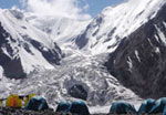
The apexes of Western Tyan-Shan covered with snow and glaciers.

The Chatkal and Kuramin ranges border on north with Fergana valley. From east she borders with Fergana range, from south with Alay and Turkestan ranges. To north-west from Turkestan range raises the Malguzar range, to south-west Chumkartau range. Only the north slopes of Chumkartau entering on territory of Uzbekistan. The valley of Sanzar river separate the Malguzar mountains from Nuratau mountains. The weak point in this valley named Tamerlan gates.

The Nuratau mountains stretch on 180 km. Their north slope is steep, the south slope is gently sloping. The high point of North part of Nuratau mountains is Khayatbashi apex (2165 m). The south part of Nuratau mountains consists from separate apexes (Aktau, Karatau, Karagatau, Gabduntau).

On the south and as parallel to Turkestan range located Zarafshan range. With self eastern part he entering on territory of Tadjikistan. On south from Zarafshan range located Gissar range and his south-western spurs (Yakkobag, Surkhantau, Kugikantau, Baysuntau, Chakgar and other). Here located the highest point of Uzbekistan - the Khazret Sultan (4643 m).

In western part of Gissar range are two glaciers - Batirbay and Severcev. On south of Uzbekistan along of border with Tadjikistan located Babatag range. The high point - Zarkasa (2292 m). The main features of orography of Uzbekistan connected with features of geological structure of above-mentioned the mountain systems.

Fann Mountains Trekking in Fann Mountains

This bond found expression in these, that between mountain ranges located spacious foothill and intermountain depressions, the large from which is Tashkent-Golodnosteppe, Fergana Zarafshan, Kashkadarya and Surkhandarya.


Please note that Uzbekistan's fourthousanders (Uzbekistan's Mountain Peaks, which are above four thousands meters high) are located in border areas. For example the Khazret Sultan Peak, the highest point of Uzbekistan (4,643 m), is located on the border between Uzbekistan and Tajikistan, in Surkhandarya Province, in the Uzbek part of the Gissar Range. The Adelung Peak (4,301 m) the highest peak in Pskem Range in extreme north-east of Uzbekistan's Tashkent Province as well as the nearby the Beshtor Peak (4,299 m), located a little further to the south-west in the same range, are situated near to Kyrgyz border. Therefore even local climbers cannot go there without a special permit. Besides, there is no transparent procedure of getting the permits to border areas, which haven't good infrastructure of tourism, into the bargain; therefore organizing of any expedition there takes enormous efforts, time and money. Knowing this most of climbers prefer the Fann mountains near to Uzbekistan with good infrastructure, Asian Patagonia of Pamiro-Alay in Kyrgyzstan, Experienced Climbing in Ala-Archa, Kyrgyzstan or the Chimgan Mountains (both, in winter and in summer) near to Tashkent.

We can offer you very interesting experience of rock climbing in the Chimgan mountains. There are routes of 1B-4B Russian grade. We can provide you with official certificate of successful climbing. We provide gears and can guarantee your success.

The suggested route is a traverse of three peaks (3A by Russian grade): the Greater Chimgan (3309 m), the Kichkina (2879 m) and the Aukashka (3099 m). It will take 4-5 days. Magnificent landscapes and challenge rock climbing. You can see a picture of proposed route below.


West Tien-Shan Mountains Map
 Uzbekistan Mountain Climbing Chimgan Mountains Trekking Chimgan Photos

Suggested route. Traverse of three peaks


Day 1 Transfer from Tashkent to Beldersay (80 km, 2 hrs.). Walking along the gorge of the Beldersay River to the Chet-Kumbel Pass (1880 m). Overnight stay in tents on the picturesque glade. Camp 1.

Day 2 Walking along the good path to the upper Beldersay river. Ascend to the Kumbel Pass (2550 m). Climbing along the southern slopes to the Greater Chimgan Peak (3,309 m), descent to the Komsomolec Pass (2700 m). Camp 2.

Day 3 Climbing to the Kichkina (2879 m) and the Aukashka (3099 m) Peaks. Magnificent landscapes and challenge rock climbing. Return to Camp 2

Day 4 Descending from the Komsomolec pass to the gorge of the Mazarsay River. Hiking to the place called "Vodoprovod". Camp 3 near the spring

Day 5 Descending to the gorge of Gulkamsay river. Visiting the Gulkam canyon. In the afternoon passing through the Pesocniy pass (1,832 m) to the valley of Chimgansay river. Collected by car. Return to Tashkent.


See the map ...


Trek Price Per Person
Individual: US$ 300
2 Pax: US$ 163
3, 7, 12 Pax : US$ 120
4-5 Pax: US$ 110
6 Pax: US$ 138
8-10 Pax: US$ 110
11 Pax: US$ 130

Transportation Tashkent-Chingan-Tashkent isn't Included. Personal Equipment isn't Included. Mountain guide service - included. Guide/Climber Ratio: 1:5 maximum limit. The rent of the tents is included for all period of expedition. Food, kitchen and climbing gears - included. Porter service is available for an additional payment ($20/day).
The price does not include: personal travel insurance; personal equipment, alcohol, personal expenses.


Chimgan Mountain Routes
 Chimgan Mountain Routes
Chimgan Mountain Routes

Uzbekistan Mountains near to Tashkent


Chimgan Mountains

The Chimgan Mountains are invariably attractive for mountaineers. The wide variety of Chimgan and its surroundings allows the activity in all kinds of mountaineering and landscape tourism. Mountains  (Small and Greater Chimgan Peaks - 3,309 m) of Chatkal range, plateaus, the Black Waterfall (40 m) at the lower part of Greater Chimgan Peak, Gulkam and Novotasha waterfalls, attract a lot of tourists from Uzbekistan and abroad.

The Greater Chimgan Mountain (3,309 m) of the Chatkal Mountain range (the Western Tian Shan) is located in the territory of the Ugam-Chatkal National Park, and it is in the Bostanlyk administrative district (Tashkent Province), Uzbekistan. The Chimgan village was settled 400-500 years ago in the mountain massive of dominant the Greater Chimgan peak (3,309 m), at an altitude of 1,620 m.

Some experts see Chinese words in the name "Chimgan" but others translate it as "sod" or "pasture abundant in water, green valley". For generations of those, who live in Tashkent province, the Greater Chimgan Mountain is the place of romantic gravitation.

The Greater Chimgan Mountain is known to mountaineers since the beginning of the 20 century. For those who want to experience of rock climbing, hiking and mountaineering Chimgan Highlands caters many opportunities. Chimgan Highlands have been a host for many other outdoor activities such as hang gliding, skiing, snowboarding and horseback riding. For many years the Greater Chimgan was the first challenge for thousands beginners of Soviet mountaineering. A great number of routes of several levels of complexity (from 1B to 4B inclusively) allows a wide spectrum of mountaineering. Beginners at climbing usually take on the uncomplicated Western Ridge of the Greater Chimgan Mountain (1B Russian grade), while there are plenty of more complicated routes for experienced climbers.

Chimgan Mountains Trekking Chimgan Photos West Tien-Shan Mountains Map


Suggested Trekking Routes

Route 1: Around the Greater Chimgan Peak (trekking)

Day 1 Transfer from Tashkent to Beldersay (80 km, 2 hrs.). Walking along the gorge of the Beldersay river to the Chet-Kumbel pass (1880 m). Overnight stay in tents on the picturesque glade. Camp 1.

Day 2 Short day. Walking along the good path to the upper Beldersay river. Ascend to the Kumbell pass (2550 m). Camp 2 near the spring.

Day 3 Very tense day. Climbing along the southern slopes to the summit of Greater Chimgan Peak (3,309 m), descent to the Komsomolec pass (2700 m). Camp 3.

Day 4 Descending from the Komsomolets pass to the gorge of the Mazarsay river. Walking to the place called "Vodoprovod". Camp 4 near the spring

Day 5 Descending to the gorge of the Gulikamsay River. Visiting the Gulikam canyon. In the afternoon passing through Pesochniy pass (1,830 m) to the valley of the Chimgansay river. Collected by car. Return to Tashkent.


See the map ...


Trek Price Per Person
Individual: US$ 300
2 Pax: US$ 163
3, 7, 12 Pax : US$ 120
4-5 Pax: US$ 110
6 Pax: US$ 138
8-10 Pax: US$ 110
11 Pax: US$ 130


Transportation Tashkent-Chingan-Tashkent isn't Included; Personal Equipment isn't Included. Mountain guide service - included. Guide/Climber Ratio: 1:5 maximum limit. The rent of the tents is included for all period of expedition. Food, kitchen and climbing gears - included.
Porter service is available for an additional payment ($20/day).
The price does not include: personal travel insurance; personal equipment, alcohol, personal expenses.


Route 2: Beldersay ring (trekking).

Day 1 Moving to the Beldersay river valley to the junction of the Beldersay River and the Marble  Rivulet. (75 km, 2 h). This is the starting point of the route. Climbing to the left shore of the Marble Rivulet which takes 2,5 — 3 hours. Stop at the birch grove. Camp. Resting and walking around. Acclimatization and preparation for the next day.

Day 2 Breakfast. Climbing to the Urta-Kumbel Pass (1850 m), 1 hour. Beautiful view opens up from the pass to the Chirchik river valley and the Chet-Kumbel pass. Gentle slope leads to the small grove at the shore of the Beldersay river. After short rest continue passing under saddle of the Chet-Kumbel pass. Camp.

Day 3 After breakfast four-hour walk towards rock paintings. Returning to the camp, lunch. Go down along the Beldersay River valley. Departure by car to Tashkent.

See the map ...

Trek Price Per Person

Individual: US$ 180
2 Pax: US$ 97,5
3, 7, 12 Pax : US$ 72
4-5 Pax: US$ 63
6 Pax: US$ 84
8-10 Pax: US$ 63
11 Pax: US$ 78


Transportation Tashkent-Chingan-Tashkent isn't Included; Personal Equipment isn't Included. Mountain guide service - included. Guide/Climber Ratio: 1:5 maximum limit. The rent of the tents is included for all period of expedition. Food, kitchen and climbing gears - included.
Porter service is available for an additional payment ($20/day).
The price does not include: personal travel insurance; personal equipment, alcohol, personal expenses.


General hiking routes in Chimgan-Beldersay area near to Tashkent

• 1-day hiking to the Small Chimgan peak (2,100 m) through Pesochniy pass (Gulkam);

• 1-day hiking through Pesochniy pass (1,830 m) and Gulkam canyon (ravines); waterfalling;

• 1-day scrambling to the Great Chimgan (3,309 m) of Chatkal ridge;

• 1-day hiking to Kyzyl-Jar peak (1,866 m) of Kungurbuka ridge.

See the map ...  


Suggested Route: Hiking in West Tien Shan

Driving from Tashkent through Galvasay village to the recreation zone "Chimgan" at the foothill of Chatkal range in West Tien Shan (100 km, 1,5 hours, 1,300 m). Going up by a good path to the Pesochniy pass (1,832 m). Descending to the gorge of the Gulkamsay river. After rest in the birch grove go through one of the most beautiful places in the mountains of Uzbekistan - the Gulkam canyon. Canyoning. Rock chap at times converging up to 5 m having numerous small waterfalls, baths, rock gorges and with frequent wades can be walked through in 2 hours. Lunch is organized in the picturesque grove at the end of canyon. After rest crossing on the country road around the Smaller Chimgan Peak (2,100 m). Majestic panorama of Ugam, Pskem and Koksu ranges of the West Tien Shan surrounding Charvak water reservoir opens up from the road. After 3 hours drive arrival in Chimgan village. Departure by car to Tashkent along Charvak reservoir. See the map ...
 
Tien-Shan Trekking - Trekking in the Tien Shan Mountains

Price for one day of all routes hiking program

1pax - U$ 55
2pax - U$ 27,5
3pax - U$ 18,3
4pax - 7pax - U$16
Mountain Guide included, Mountain gear included, One meal included. Local transportation isn't included.


ClimberCA - Osthofen - Moscow - Tashkent - Dushanbe - Bishkek - Urumchi - Skardu - Hanoi
Tel. +99898 303 9846, +99890 188 61 28, +99890 352 7483 - e-mail: your.climberca@ya.ru
ClimberCA
 
 Copyright © ClimberCA