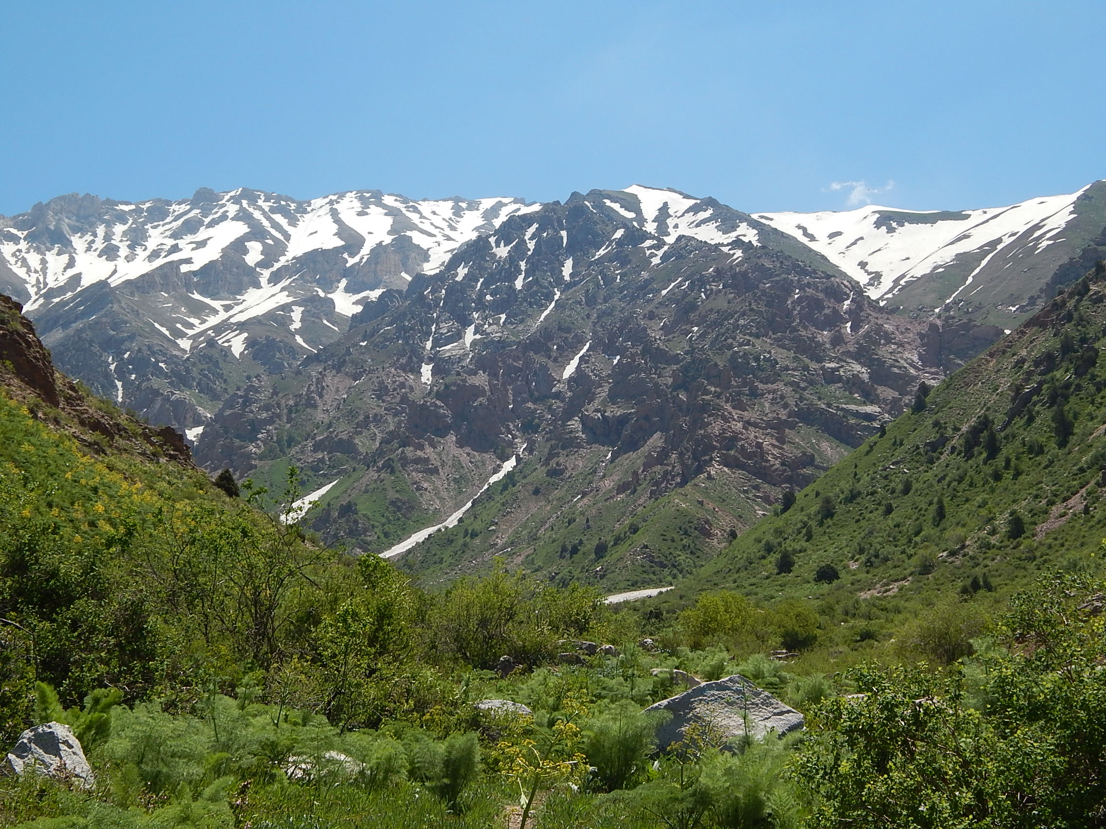
Gelon plus climbing the Hazrat Sultan holy peak

Coordinates: 39°04’N 67°27’E

Gelon is a settlement in the Shakhrisabz district of the Kashkadarya region of the Republic of Uzbekistan.

The village was founded in 1305. The inhabitants of the village still keep the ancient customs and way of life. Until mid-2018, foreign tourists could not visit this village due to the special border regime.

Geography

Gelon is located in the southern part of Uzbekistan in Kashkadarya, on the western slopes of the Pamir-Alai mountains.

The territory is located on the border of Uzbekistan and Tajikistan, 80 kilometers from Shakhrisabz. The village is surrounded on all sides by high mountains, reaching heights of more than 4,000 meters in the east. This is one of the highest mountain villages in Uzbekistan. It is not easy to get here along a difficult but picturesque mountain dirt road with numerous serpentines.

Climate

The climate is continental, dry, subtropical in places.

Population

The population of the village is 5834 people (2019). The overwhelming majority of people here are Tajiks.

Interesting fact

Gelon is located at an altitude of 2600 meters above sea level. In the vicinity of the village there are practically no flat plots of land where a tractor could be used, and the peasants are forced to cultivate potato fields on steep mountain slopes reaching 40 degrees, using a simple plow pulled by a pair of bulls or donkeys. Orchards are also grown on steep slopes and in river gorges.

Peculiarities of local life in the village of Gelon

A special pride of the inhabitants of the village is an extensive irrigation network of artificial canals laid along the slopes of the mountains for tens of kilometers. The most famous mountain potatoes in Uzbekistan grow here. Especially exotic is the central part of the village with old houses and narrow streets.

The second floor of the house here is residential, and the first floor is used for keeping livestock. The same architecture is used in Tibet and in the highlands of Nepal. In the village, tourists can get acquainted with the life of the inhabitants, take a walk for 1-3 days in the picturesque surroundings, as well as in the neighboring villages Kul, Shut, Sarchashma.

A river of the same name flows through Gelon. In the village there are interesting local artists, musicians who actively take part in various events, weddings.

Gelon is the oldest settlement in the region and is considered the richest in the Kashkadarya region. The main activities in Gelon are planting potatoes, cultivating watermelons, fruits and raising livestock. All residents of the village are Muslims, they also hold weddings in accordance with Muslim Sharia rituals. Girls get married at the age of 18. A resident of Gelon is obliged to keep his wife clean and safe, to read sacred prayers, not to drink alcohol and not to smoke. At the beginning of the 20th century, when the revolution began, the Basmachi movement was developed in the village.

At the moment, the Gelon settlement has the largest number of centenarians. Its inhabitants reach 85-90 years. Here you can easily see a man who is over 85, and he will be the embodiment of health and strength.

Tourism

Not far from the village of Gelon is the holy mountain “Khazrati Sultan”, where thousands of tourists come to pray (Not to be confused with the highest point of Uzbekistan (4643 m.), Which is located on the Gissar Range in the Sariasiya district of the Surkhandarya region, on the Uzbek-Tajik border. In 1964 the first ascent of this mountain was made, it was given the name after the XXII Congress of the Central Committee of the CPSU. But there are no documents left from that expedition, just as no documents from other expeditions were found. It is known for certain that Uzbek climbers climbed this peak in 2010. Approaches to the peak from Uzbekistan are very difficult, so many expeditions tried to climb the mountain from the side of Tajikistan, the village of Sarytag, near Iskandarkul Lake).

Also, being in the village, you can visit one of the most spectacular and abundant waterfalls in Uzbekistan, the 40-meter waterfall “Suvtushar”. On the way to the village, guests pass by the Hissar reservoir, which is a popular place among tourists.

The best time to visit the region is from 15 June to 30 September.

Program

1 day Samarkand – Shakhrisabz – Gelon village.

Meeting in Samarkand. Transfer to Shakhrisabz. City tour. Departure to Gelon. On the way, sightseeing of the Gissarak reservoir, then moving along the picturesque gorge of the Oksu River to the village of Gelon. Accommodation in a national house at an altitude of 2200 m. Walking around the village, visiting the house of the artist Muhammadi, the central mosque and teahouse. Visit to the village museum.

Travel time from Samarkand to Gelon village 4-5 hours, 175 km.

Day 2 Gelon village – Mukhbel pass.

Departure through the Urtabel pass (2466 m.) to the Kul village, then through the Serketartar pass (2537 m.), Baturbai gorge and Mirny pass (3150 m.), to the Khonako gorge and ascent under the Mukhbel pass. Setting up a camp at an altitude of 3100 m, accommodation in tents.

Travel time 3 – 4 hours, 35 km.

Day 3 Peak Hazrat Sultan – the village of Gelon.

Early in the morning ascent to the top of Hazrat Sultan (4083 m.)

Hazrat Sultan is a place of pilgrimage for Muslims. This shrine is known far beyond the borders of Uzbekistan. The grave of Hazrat Dovud is located at the very top. Here you will learn about the life and exploits of Hazrat Dovud. A magnificent panorama of the Gissar and Zeravshan mountains opens from the top. Walking time 5-6 hours, 12 km: +/-1000 m. Departure to Gelon village. Accommodation in the national house 2200 m.

Travel time 3 hours, 35 km.

Day 4 Gelan village – Shakhrisabz – Samarkand.

Departure to Samarkand. Travel time 4 – 5 hours, 175 km.

____________________________________________________________________________

Contact information

https://t.me/ClimberCA – telegram
WhatsApp / Viber +7966 065-53-44
e-mail – your@climberca.com

Tour price:

Number of people & price per person

1 – $680
2 – $570
3 – $520
4 – $475
5 – $440
6 – $420
7 – $400

The tour price includes:

– Meeting and farewell.
– Transport according to the program. / NIVA, NIVA CHEVROLET, JEEP or UAZ. 3 people in 1 car/
– Accommodation according to the program.
– Full board meals.
– Services of an interpreter guide / English or German /
– Entrance tickets to historical monuments in Shakhrisabzs.
– Museum, artist and blacksmith visit, local folklore.
– Mountain guide services.
– Cooking services, kitchen utensils, gas.

The tour price does not include:

Border pass, to visit the border area – $ 30.

Uzbekistan Mountain Climbing

Uzbekistan mountains

Uzbekistan Mountain Climbing (Mountaineering) – Ascending mountains

Gelon plus climbing the Hazrat Sultan holy peak

Coordinates: 39°04’N 67°27’E

Gelon is a settlement in the Shakhrisabz district of the Kashkadarya region of the Republic of Uzbekistan.

The village was founded in 1305. The inhabitants of the village still keep the ancient customs and way of life. Until mid-2018, foreign tourists could not visit this village due to the special border regime.

Geography

Gelon is located in the southern part of Uzbekistan in Kashkadarya, on the western slopes of the Pamir-Alai mountains.

The territory is located on the border of Uzbekistan and Tajikistan, 80 kilometers from Shakhrisabz. The village is surrounded on all sides by high mountains, reaching heights of more than 4,000 meters in the east. This is one of the highest mountain villages in Uzbekistan. It is not easy to get here along a difficult but picturesque mountain dirt road with numerous serpentines.

Climate

The climate is continental, dry, subtropical in places.

Population

The population of the village is 5834 people (2019). The overwhelming majority of people here are Tajiks.

Interesting facts

Gelon is located at an altitude of 2600 meters above sea level. In the vicinity of the village there are practically no flat plots of land where a tractor could be used, and the peasants are forced to cultivate potato fields on steep mountain slopes reaching 40 degrees, using a simple plow pulled by a pair of bulls or donkeys. Orchards are also grown on steep slopes and in river gorges.

Peculiarities of local life in the village of Gelon

A special pride of the inhabitants of the village is an extensive irrigation network of artificial canals laid along the slopes of the mountains for tens of kilometers. The most famous mountain potatoes in Uzbekistan grow here. Especially exotic is the central part of the village with old houses and narrow streets.

The second floor of the house here is residential, and the first floor is used for keeping livestock. The same architecture is used in Tibet and in the highlands of Nepal. In the village, tourists can get acquainted with the life of the inhabitants, take a walk for 1-3 days in the picturesque surroundings, as well as in the neighboring villages Kul, Shut, Sarchashma.

A river of the same name flows through Gelon. In the village there are interesting local artists, musicians who actively take part in various events, weddings.

Gelon is the oldest settlement in the region and is considered the richest in the Kashkadarya region. The main activities in Gelon are planting potatoes, cultivating watermelons, fruits and raising livestock. All residents of the village are Muslims, they also hold weddings in accordance with Muslim Sharia rituals. Girls get married at the age of 18. A resident of Gelon is obliged to keep his wife clean and safe, to read sacred prayers, not to drink alcohol and not to smoke. At the beginning of the 20th century, when the revolution began, the Basmachi movement was developed in the village.

At the moment, the Gelon settlement has the largest number of centenarians. Its inhabitants reach 85-90 years. Here you can easily see a man who is over 85, and he will be the embodiment of health and strength.

Tourism

Not far from the village of Gelon is the holy mountain “Khazrati Sultan”, where thousands of tourists come to pray (Not to be confused with the highest point of Uzbekistan (4643 m.), Which is located on the Gissar Range in the Sariasiya district of the Surkhandarya region, on the Uzbek-Tajik border. In 1964 the first ascent of this mountain was made, it was given the name after the XXII Congress of the Central Committee of the CPSU. But there are no documents left from that expedition, just as no documents from other expeditions were found. It is known for certain that Uzbek climbers climbed this peak in 2010. Approaches to the peak from Uzbekistan are very difficult, so many expeditions tried to climb the mountain from the side of Tajikistan, the village of Sarytag, near Iskandarkul Lake).

Also, being in the village, you can visit one of the most spectacular and abundant waterfalls in Uzbekistan, the 40-meter waterfall “Suvtushar”. On the way to the village, guests pass by the Hissar reservoir, which is a popular place among tourists.

The best time to visit the region is from 15 June to 30 September.

Program

1 day Samarkand – Shakhrisabz – Gelon village.

Meeting in Samarkand. Transfer to Shakhrisabz. City tour. Departure to Gelon. On the way, sightseeing of the Gissarak reservoir, then moving along the picturesque gorge of the Oksu River to the village of Gelon. Accommodation in a national house at an altitude of 2200 m. Walking around the village, visiting the house of the artist Muhammadi, the central mosque and teahouse. Visit to the village museum.

Travel time from Samarkand to Gelon village 4-5 hours, 175 km.

Day 2 Gelon village – Mukhbel pass.

Departure through the Urtabel pass (2466 m.) to the Kul village, then through the Serketartar pass (2537 m.), Baturbai gorge and Mirny pass (3150 m.), to the Khonako gorge and ascent under the Mukhbel pass. Setting up a camp at an altitude of 3100 m, accommodation in tents.

Travel time 3 – 4 hours, 35 km.

Day 3 Peak Hazrat Sultan – the village of Gelon.

Early in the morning ascent to the top of Hazrat Sultan (4083 m.)

Hazrat Sultan is a place of pilgrimage for Muslims. This shrine is known far beyond the borders of Uzbekistan. The grave of Hazrat Dovud is located at the very top. Here you will learn about the life and exploits of Hazrat Dovud. A magnificent panorama of the Gissar and Zeravshan mountains opens from the top. Walking time 5-6 hours, 12 km: +/-1000 m. Departure to Gelon village. Accommodation in the national house 2200 m.

Travel time 3 hours, 35 km.

Day 4 Gelan village – Shakhrisabz – Samarkand.

Departure to Samarkand. Travel time 4 – 5 hours, 175 km.

____________________________________________________________________________

Contact information

https://t.me/ClimberCA – telegram
WhatsApp / Viber +7966 065-53-44
e-mail – your@climberca.com

Tour price:

Number of people & price per person

1 – $680
2 – $570
3 – $520
4 – $475
5 – $440
6 – $420
7 – $400

The tour price includes:

– Meeting and farewell.
– Transport according to the program. / NIVA, NIVA CHEVROLET, JEEP or UAZ. 3 people in 1 car/
– Accommodation according to the program.
– Full board meals.
– Services of an interpreter guide / English or German /
– Entrance tickets to historical monuments in Shakhrisabzs.
– Museum, artist and blacksmith visit, local folklore.
– Mountain guide services.
– Cooking services, kitchen utensils, gas.

The tour price does not include:

Border pass, to visit the border area – $ 30.

Traverse of three peaks: Rock climbing, Free climbing, Scrambling

Traverse of three peaks: Rock climbing, Free climbing, Scrambling


Day 1
Transfer from Tashkent to Beldersay (88 km, 2 hrs.). Walking along the gorge of the Beldersay River to the Chet-Kumbel Pass (1880 m). Overnight stay in tents on the picturesque glade. Camp 1.
Day 2 Walking along the good path to the upper Beldersay river. Ascend to the Kumbel Pass (2550 m). Climbing along the southern slopes to the Greater Chimgan Peak (3,309 m), descent to the Komsomolec Pass (2700 m). Camp 2.
Day 3 Climbing to the Kichkina (2879 m) and the Aukashka (3099 m) Peaks. Magnificent landscapes and challenge rock climbing. Return to Camp 2
Day 4 Descending from the Komsomolec pass to the gorge of the Mazarsay River. Hiking to the place called “Vodoprovod”. Camp 3 near the spring.
Day 5 Descending to the gorge of Gulkamsay river. Visiting the Gulkam canyon. In the afternoon passing through the Pesocniy pass (1,832 m) to the valley of Chimgansay river. Collected by car. Return to Tashkent.
See the map …

Trek Price Per Person
Individual: US$ 600
2 Pax: US$ 335
3 Pax : US$ 270
4 Pax: US$ 217
5 Pax: US$ 200

Transportation Tashkent-Chingan-Tashkent isn’t Included; Personal Equipment isn’t Included. Mountain guide service – included. Guide/Climber Ratio: 1:5 maximum limit. The rent of the tents is included for all period of trek. Food (survival ration), kitchen and climbing gears – included. Porter service is available for an additional payment. The price does not include: personal travel insurance; personal  equipment, alcohol, personal expenses.

Uzbekistan mountains

The mountains of Uzbekistan enter in structure of Tyan-Shan and Alay mountain systems. On territory turn the western spurs of Tyan-Shan and Gissar-Alay mountain system. To south and west they gradually lower and turn to plains.

Internal (tectonic) power of Earth formed folds grown the powerful ranges of mountains.

The mountains and foothills with brook relief, located in east and south-east part of Uzbekistan, where they unite with powerful mountain
deep brook massive on territory of Kirgizya and Tadjikistan. Mainly this UgamPskemChatkalKuramin ranges and their western and  south-western spurs, concerning to Western Tyan-Shan system and TurkestanZerafshan and Gissar ranges with their continuous on  south-western – Babatag and Kugintangtau ranges, concerning to Gissar-Alay system.

Entering on territory of Uzbekistan its spurs formed radiating bundle of mountain chains, constantly less in north-western and south-western directions. The character example is KarjantauMaygashkan and Surenata ranges in western Tyan-Shan system and NuratauAktau and Kuratau ranges and Karatepa and Ziadin-Zirabulak mountains, being the last of Pamir-Alay.

Entering in Western Tyan-Shan system the mountain ranges (Karjantau, Ugam, Pskem, Chatkal, Kuramin) began from Talass Alatau (on border with Kirgizstan), further as fan radiate from here and continuos to north-east to south-west.

The more high point of Talass Alatau is mountain Manas (4482m). The high point of Chatkal range on territory of Uzbekistan – Greater
Chimgan peak
 (3309 m). Between Chatkal and Kuramin ranges located Akhangaran valley.

The apexes of Western Tyan-Shan covered with snow and glaciers.

The Chatkal and Kuramin ranges border on north with Fergana valley. From east she borders with Fergana range, from south with Alay and Turkestan ranges. To north-west from Turkestan range raises the Malguzar range, to south-west Chumkartau range. Only the north slopes of Chumkartau entering on territory of Uzbekistan. The valley of Sanzar river separate the Malguzar mountains from Nuratau  mountains. The weak point in this valley named Tamerlan gates.

The Nuratau mountains stretch on 180 km. Their north slope is steep, the south slope is gently sloping. The high point of North part of Nuratau mountains is Khayatbashi apex (2165 m). The south part of Nuratau mountains consists from separate apexes (Aktau, Karatau, Karagatau, Gabduntau).

On the south and as parallel to Turkestan range located Zarafshan range. With self eastern part he entering on territory of Tadjikistan. On south from Zarafshan range located Gissar range and his south-western spurs (Yakkobag, Surkhantau, Kugikantau, Baysuntau,  Chakgarand other). Here located the highest point of Uzbekistan – the Khazret Sultan (4643 m).

In western part of Gissar range are two glaciers – Batirbay and Severcev. On south of Uzbekistan along of border with Tadjikistan located Babatag range. The high point – Zarkasa (2292 m). The main features of orography of Uzbekistan connected with features of geological structure of above-mentioned the mountain systems.

This bond found expression in these, that between mountain ranges located spacious foothill and intermountain depressions, the large from which is Tashkent-GolodnosteppeFergana ZarafshanKashkadarya and Surkhandarya.

Uzbekistan Mountains near to Tashkent

Chimgan Mountains

The Chimgan Mountains are invariably attractive for mountaineers. The wide variety of Chimgan and its surroundings allows the activity in all kinds of mountaineering and landscape tourism. Mountains  (Small and Greater Chimgan Peaks – 3,309 m) of Chatkal range,  plateaus, the Black Waterfall (40 m) at the lower part of Greater Chimgan PeakGulkam waterfalls, attract a lot of tourists from  Uzbekistan and abroad.

Ugam & Karjantau ridges

Another attractive place for mountaineering is situated on Ugam ridge and on the southern; slopes of the Karjantau ridge of the Western
Tyan-Shan system
. There are following natural sites, which are of interest of mountaineers in area of Ugam & Karjantau ridges:

  • Peak Mingbulak(2,628 m)  – the highest peak of the Karjantau ridge.
  • Qizilsuv waterfalls– the pictorial cascades that flow at the sinuous river gorges of Qizilsuv Mountain River.
  • Loquacious caveis located on plateau Ghiza, 20 km from village Humsan, in a funnel-shaped hollow. On the bottom of the hollow, in the exposure of grey limestone, there is a 1×1 m rectangular aperture transforming to a 1.5 m high sloping tunnel. Its floor is covered with
    lumps, ceiling being arcaded. This tunnel is 20 m long and leads to the inner larger part of the cave. A ladder is needed in order to proceed
    into the cave as there is a 6 m high prominence. Then the floor levels out, height reaching 20-30 m. The cave is so named due to a  treamlet flowing through it.
  • Arkutsay– exposure of loess stratum. The site is 3 km west of Humsan, on the right bank of the Ugam River. Section of the formation represents the wall of a small landslide breakaway and is a stratum of interstratifying loess-like loams of Quaternary and fossil soils horizons. The section is unique as it exposes more than 80 m thick deposition of rocks.
  • Kyrk-Kokyl waterfall(in Uzbek “Kyrk-Kokyl” means 40 plaits) – pictorial waterfall at Pustonlyk – confluent of Ugam River, 9 km from  Humsan village.


Fann Mountains Trekking in Fann Mountains


Tien-Shan Trekking

Trekking in the Tien Shan Mountains

Tien-Shan Trekking – Trekking in the Tien Shan Mountains

Key Information

Tour Duration:
11 day(s)
Group Size: 1 – 14 people


Destination:
 Uzbekistan
Location: West Tien-Shan Mountains
Specialty Categories: Mountain Trekking/Mountain Climbing
Grade: Moderate to fairly challenging


Season:
 
June – October
International Airfare Included: No
Local Transportation Included: Yes
Foodstuffs (survival ration) Included: Yes
Personal Travel Insurance Included: No
Personal Equipment Included: No
Tour Customizable: Yes

Mountain Guides
Service Included:
 Yes
Porters Availability: Yes
Cook Availability: Yes
Guide/Climbers Ratio: beginners – 1:5; advanced – 1:7 (maximum
limit)
Download a Map: 2736×1920 1,25 МБ (1 314 816 байт)


Trek Price Per Person – 


Contact information

https://t.me/ClimberCA
 – telegram
WhatsApp / Viber +7966 065-53-44
e-mail – your@climberca.com


Day 1
Мар.
We start from the Railroad station in Tashkent at around 8 o’clock in the morning. In about two hours we arrive by train to the Hojikent station. It is a first point of the trek, which is located at a height of 880 m. We start climbing southward following the Bulaksu River back to its sources. Halfway rest, lunch under the shady trees near to one of the Bulaksy River’s sources. After lunch we continue climbing toward the Bulaksu Pass 1900 m (+1020 m). You get a splendid view of the Chimgan area from the Bulaksu Pass. There is water welling up from the earth near to this pass. This is a place of the first camp.


Trekking in the Tien Shan Mountains

This is a starting point of the trek, which is located at a height of 880 m. We start climbing southward following the Bulaksu River back to its sources and  then continue climbing toward the Bulaksu Pass 1900 m

Trekking in the Tien Shan Mountains

View back to the ravine of the Bulaksu River. At a  distance – the Karjantau Ridge and the Chirchik River.


Note: 
For the first two days you will have minimum of package, all your spare packages will meet you at the end of second day in Camp 2.


Trekking in the Tien Shan Mountains

You get a splendid view of the Chimgan area from the Bulaksu Pass.

Trekking in the Tien Shan Mountains

View to the the Akshurang Pass (1735 m) from  the place of first camping.


Day 2
Map.
Today we make our way towards the Greater Chimgan Mountain. We pass Akshurang then climb to the Mingtukum Mountain (1960
m), walk down the ridge to the Archaly Pass (1595 m) and then hike a bit eastward to Kiziljar. This is a place of our camp 2. Towards evening we climb to the Kiziljar Mountain (1900 m) in order to take pictures of the Greater Chimgan Mountain from arguably the most  optimal earth-based view point. 


Trekking in the Tien Shan Mountains

The Kiziljar (Red Steep) Mountain (1900 m) and the Greater Chimgan Mountain (3309 m) – the highest point of this trek, soon you will be there.

Trekking in the Tien Shan Mountains

View of the Greater Chimgan Mountain from arguably the most  optimal earth-based view point.


Day 3
Map.
Repackaging in order to take outfit and foodstuff for the next 6 days. Use of service of the mountain porters is recommended. Our target for this day is the Beldersay river, which springs from highland between West Ridge and Southwest Ridge of the Greater Chimgan Mountain. During first half of this day we climb to West Ridge (Northwestern Spur), pass the Tahtajaylau Saddle (2190 m) and then descend to the Marble Rivulet. Halfway rest, lunch, excursion downstream of the rivulet. After rest we climb to Western Spur of West Ridge towards the Urta-Kumbel Pass (1850 m). From the pass we descend to the Beldersay River, where we set up our third  camp.


Trekking in the Tien Shan Mountains

View to the Urta-Kumbel Pass (1850 m), the Chet-Kumbel Pass (1880 m) and the Kumbel Mountain (2306 m) from the Tahtajaylau Saddle (2190 m).


Trekking in the Tien Shan Mountains

On the riversides of the Marble Rivulet th ere are plenty of petrified seashells.

Trekking in the Tien Shan Mountains

Hip bath of pure marble downstream of the Marble Rivulet.


Trekking in the Tien Shan Mountains

View to the ravines of the Shalkuma / Beldersay
revers and SW Ridge of the Greater Chimgan Mountain from the place near to the third camp.


Day 4
Map.
Today we go south-westward via the Chet-Kumbel Pass (1880 m) to the place of confluence of the Bercota River with the Nurekota River near to the Nurekota village.


Trekking in the Tien Shan Mountains

View from the Chet-Kumbel pass to the Greater Chimgan Mountain and its SW Ridge.


Trekking in the Tien Shan Mountains

View from the Chet-Kumbel pass to the Nurekota Valley, Mirzabay Ridge.
At a distance – Imetey (2731 m) and Akkul (2886 m) mountains.

Trekking in the Tien Shan Mountains

View of one of typical mountain rivers, locally called “says”.


Trekking in the Tien Shan Mountains

Pure and cool waters of a say (mountain river).

Trekking in the Tien Shan Mountains

This is how a typical shepherd’s holding in Tien Shan looks like.


Day 5
MapMap.
Climb up the Akkul Ridge – reach the Imetey Mountain (2731 m) – roundabout the Akkul Mountain (2886 m) – set up a camp before one reaches the Aksakota Pass.


Trekking in the Tien Shan Mountains

Mountain Ridge in West Tien Shan’s highland.

Trekking in the Tien Shan Mountains

Nearly mountain peak.

Trekking in the Tien Shan Mountains

Roundabout the mountain peak.


Day 6
Map.
Climb up the Aksakota Pass (2450 m) – move to the Minjilki Ridge – hike northeast by the ridge via the Karangur Mountain (2942 m) and the 2852 m Mountain to the Pulathan Pass (2590 m) – set up a camp near head waters of the Karaarcha River.


Trekking in the Tien Shan Mountains

Mountain Ridge in West Tien Shan’s highlands.

Trekking in the Tien Shan Mountains

Passing by mountain peak.

Trekking in the Tien Shan Mountains

Mountain river head.


Day 7
Map.
Excursion to the Pulathan Plateau – return to the camp. Pulathan looks as if it has been sliced off the mountain range (highest point of the Pulathan Plateau is 2823 m). Over time, many caves have been formed by the water which accumulates there. One can climb  Pulathan only from the Pulathan Pass; it is inaccessible from the other sides.


Trekking in the Tien Shan Mountains

Panoramic view to the Pulathan Plateau from northwest.


Trekking in the Tien Shan Mountains
 Trekking in the Tien Shan Mountains Trekking in the Tien Shan Mountains
Natural Mountain environment of the West Tien Shan’s
highlands.


Day 8
Map.
Return to the Mingjilki Ridge. Transfer lengthwise the Mingjilki Ridge: the Mingjilki Mountain (2842 m), the Jar Mountain (2936 m), the Tahta Pass (2620 m). Set up a camp near the place, called Lazurnie Lujayki. In the environs of the Mingjilki Pass it is possible to explore petroglyphs picturing. The age of these rock paintings amounts many thousands years. In the area one can frequently encounter the ruins of ancient settlements, burial mounds, and, of course, petroglyphs on the rocks.


Trekking in the Tien Shan Mountains

View to the Greater Chimgan Mountain from a place near to the camp.

Trekking in the Tien Shan Mountains

View back to the Mingjilki Ridge from a place near to the camp.

Trekking in the Tien Shan Mountains

View back to the Mingjilki Ridge at sunset.


Day 9
Map.
Change of the porters, other porters, full of strength, bring fresh foodstuffs to this place for the next three and a half days. Repackaging and then ascent to the Greater Chimgan Peak (3309 m). Descent to the Komsomolec Pass (2700 m) of Central Ridge. Set up a camp.


Trekking in the Tien Shan Mountains

Climb to the Greater Chimgan Mountain from the Tahta Pass.

Trekking in the Tien Shan Mountains

View to south-eastward from southern slope of the Greater Chimgan Mountain. The Pulathan Plateau.

Trekking in the Tien Shan Mountains

On top of the Greater Chimgan Mountain (3309 m), gazing at the splendid view.


Trekking in the Tien Shan Mountains

View to the Komsomolec Pass – 2700 m.

Trekking in the Tien Shan Mountains

View from the Komsomolec Pass to the Pulathan
Plateau.


Day 10
Map.
Descent to Aukaska tract. Rivers Semizsay, Tectoshsu, Mazarsay. Crossing NE Ridge of the Greater Chimgan Mountain, descent to Kuyluksay river. Set up a camp near to the place, called Vodoprovod. Towards evening – excursion to the snowfield and rocks upriver Kuyluksay.


Trekking in the Tien Shan Mountains

Semizsay

Trekking in the Tien Shan Mountains

Tectoshsu

Trekking in the Tien Shan Mountains

Mazarsay


Trekking in the Tien Shan Mountains

Aukashka

Trekking in the Tien Shan Mountains

Mazarsay River, Yangikurgan village, Charvak water reservoir, Burchmulla village on the opposite side of the Charvak water reservoir.

Trekking in the Tien Shan Mountains

Kuiluksay River


Day 11
Map.
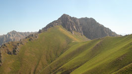
Hike to the Kuchkinakuksay River, passing picturesque gorge of the Gulikamsay river, deccent to Yangikurgan village. Hike to the shore of the Charvak vater reservoir. Set up a camp.

Trekking in the Tien Shan Mountains

Kichkinakuksay


Day 12
.
Rest ashore the Charvak Water Reservoir. Departure for Tashkent at about noon.


Trekking in the Tien Shan Mountains

View to the Charvak Water Reservoir from the standpoint near to the Ishakkupruksay River.

Trekking in the Tien Shan Mountains

View to the Charvak Water Reservoir from the standpoint near to the Kulabsay River.

Trekking in the Tien Shan Mountains

Diving to deep waters of the Charvak Water
Reservoir.


Trekking in the Tien Shan Mountains

View to south-eastward from the place of last camp. From right to left: the Aukashka spur, completed with the Patandozbashi Mountain 1877 m; the Aukashka Mountain 3099 m; the Chatkal River; the Imanhan Mountain (2363 m); the Paltau Mountain (2023 m).