Trekking & Adventure Tours in Central Asia

Trekking and Adventure Tours in Central Asia: Uzbekistan & the Fann Mountains

Central Asia is rapidly becoming one of the most attractive destinations for trekking, hiking, and mountaineering tours. Thanks to improved infrastructure and simplified border procedures, Uzbekistan and Tajikistan now offer a unique opportunity to combine legendary Silk Road cities with world-class mountain trekking.

Our adventure tours are designed for travelers who want authentic experiences, flexible routes, and professional local support.


Trekking in Uzbekistan

Uzbekistan offers excellent options for short trekking programs and active day tours, especially in the mountains near Tashkent.

The most popular region is the Chimgan–Beldersay area, where we organize:

  • Guided one-day hikes

  • Mountain walks with panoramic views

  • Horseback riding tours

  • Seasonal white-water rafting (until late May)

These programs are ideal as an active extension to cultural tours in Tashkent, Samarkand, and Bukhara.


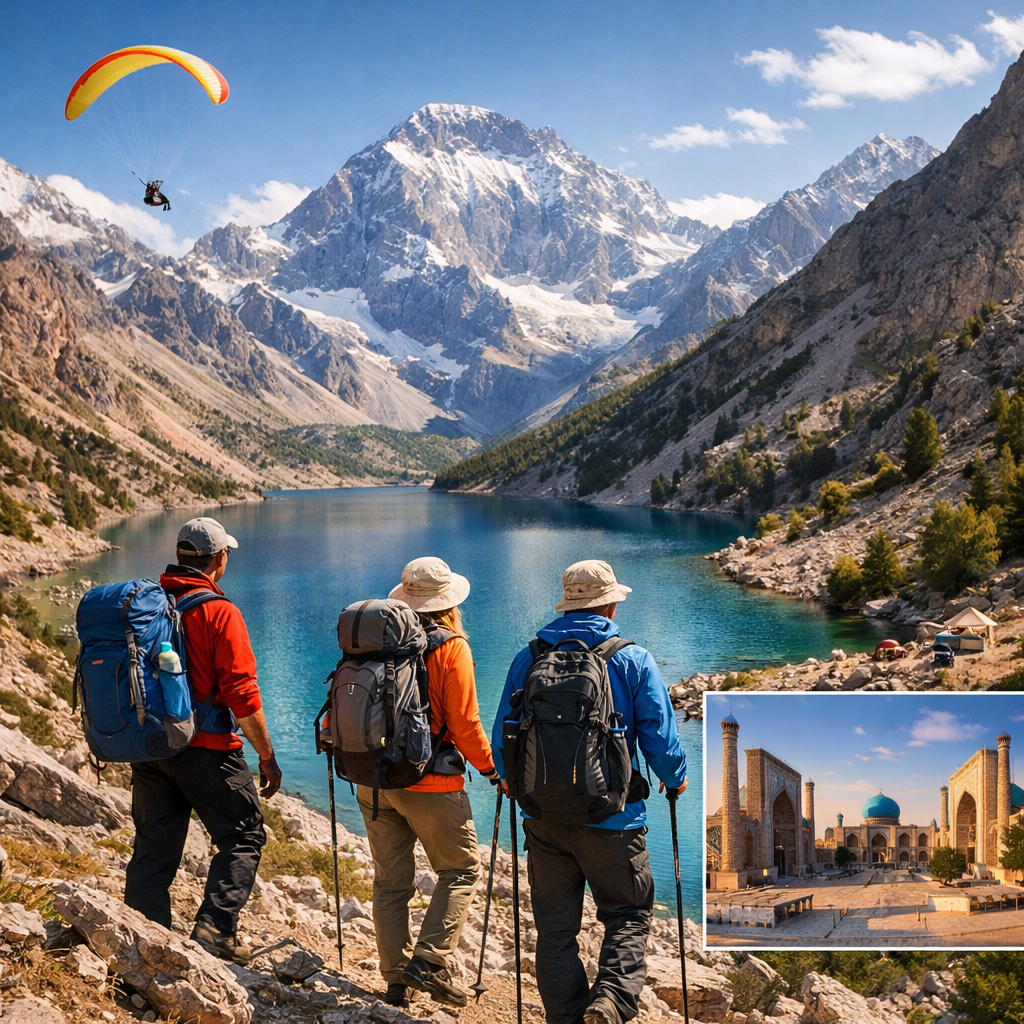
Fann Mountains Trekking (Tajikistan)

For travelers looking for multi-day trekking and true alpine landscapes, the Fann Mountains are the highlight of any Central Asia adventure.

Located just a few hours from Samarkand, the Fann Mountains offer:

  • Crystal-clear alpine lakes

  • High mountain passes and glaciers

  • A wide choice of trekking routes (from moderate to challenging)

  • No special permits or restricted zones

  • Excellent conditions for trekking, hiking, and light mountaineering

This region is considered one of the best trekking destinations in Central Asia.


Combined Cultural & Trekking Tours

We specialize in combined itineraries that seamlessly connect Uzbekistan’s cultural heritage with mountain adventures in Tajikistan.

A classic combined route includes:

Tashkent – Bukhara – Samarkand – Fann Mountains – Samarkand – Tashkent

This itinerary allows travelers to:

  • Explore UNESCO World Heritage cities

  • Discover Silk Road history

  • Enjoy professionally guided trekking in the Fann Mountains

  • Travel comfortably with full logistical support


Continue reading

Uzbekistan mountains

The mountains of Uzbekistan enter in structure of Tyan-Shan and Alay mountain systems. On territory turn the western spurs of Tyan-Shan and Gissar-Alay mountain system. To south and west they gradually lower and turn to plains.

Internal (tectonic) power of Earth formed folds grown the powerful ranges of mountains.

The mountains and foothills with brook relief, located in east and south-east part of Uzbekistan, where they unite with powerful mountain deep brook massive on territory of Kirgizya and Tadjikistan. Mainly this Ugam, Pskem, Chatkal, Kuramin ranges and their western and south-western spurs, concerning to Western Tyan-Shan system and Turkestan, Zerafshan and Gissar ranges with their continuous on south-western – Babatag and Kugintangtau ranges, concerning to Gissar-Alay system.

Entering on territory of Uzbekistan its spurs formed radiating bundle of mountain chains, constantly less in north-western and south-western directions. The character example is Karjantau, Maygashkan and Surenata ranges in western Tyan-Shan system and Nuratau, Aktau and Kuratau ranges and Karatepa and Ziadin-Zirabulak mountains, being the last of Pamir-Alay.

Entering in Western Tyan-Shan system the mountain ranges (Karjantau, Ugam, Pskem, Chatkal, Kuramin) began from Talass Alatau (on border with Kirgizstan), further as fan radiate from here and continuos to north-east to south-west.

The more high point of Talass Alatau is mountain Manas (4482m). The high point of Chatkal range on territory of Uzbekistan – Greater Chimgan peak (3309 m). Between Chatkal and Kuramin ranges located Akhangaran valley.

The apexes of Western Tyan-Shan covered with snow and glaciers.

The Chatkal and Kuramin ranges border on north with Fergana valley. From east she borders with Fergana range, from south with Alay and Turkestan ranges. To north-west from Turkestan range raises the Malguzar range, to south-west Chumkartau range. Only the north slopes of Chumkartau entering on territory of Uzbekistan. The valley of Sanzar river separate the Malguzar mountains from Nuratau mountains. The weak point in this valley named Tamerlan gates.

The Nuratau mountains stretch on 180 km. Their north slope is steep, the south slope is gently sloping. The high point of North part of Nuratau mountains is Khayatbashi apex (2165 m). The south part of Nuratau mountains consists from separate apexes (Aktau, Karatau, Karagatau, Gabduntau).

On the south and as parallel to Turkestan range located Zarafshan range. With self eastern part he entering on territory of Tadjikistan. On south from Zarafshan range located Gissar range and his south-western spurs (Yakkobag, Surkhantau, Kugikantau, Baysuntau, Chakgarand other). Here located the highest point of Uzbekistan – the Khazret Sultan (4643 m).

In western part of Gissar range are two glaciers – Batirbay and Severcev. On south of Uzbekistan along of border with Tadjikistan located Babatag range. The high point – Zarkasa (2292 m). The main features of orography of Uzbekistan connected with features of geological structure of above-mentioned the mountain systems.

This bond found expression in these, that between mountain ranges located spacious foothill and intermountain depressions, the large from which is Tashkent-Golodnosteppe, Fergana Zarafshan, Kashkadarya and Surkhandarya.


Mountaineering in Uzbekistan

http://climberca.com/index.php/69-mountaineering-in-uzbekistan