Uzbekistan Mountain Trekking

Trekking, backpacking, tramping, bushwalking in Uzbekistan


Uzbekistan Mountain Trekking

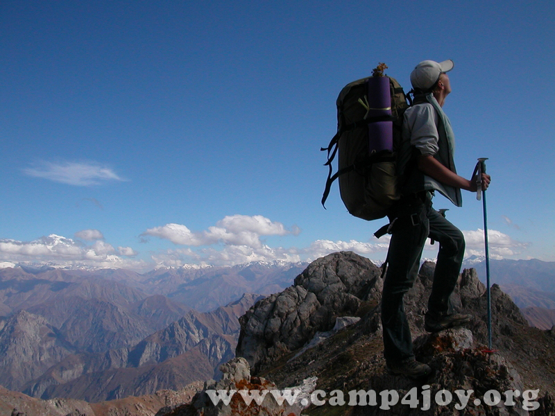
Trekking in the Nurata mountains

Mountains, Photo & Sightseeng in Uzbekistan. Sketch itinerary

Contact information

https://t.me/ClimberCA
 – telegram
WhatsApp / Viber +7966 065-53-44
e-mail – your@climberca.com

Sketch itinerary 2023

Day 1.
12.00 Arrival in the Majerum village, accommodation in a guest house. The guest house has 4 rooms (15 beds).
13.00 Lunch.
14.00-18.00 Hike around the village (4 km)
19.00 Dinner.

Day 2. Hike
from the Majerum village to the Hayat village.
7.00 Breakfast.
8.00-12.00 Visiting a water mill, the 2000-year-old Oriental biota tree and the ruins of an ancient mosque in the Majerumsay valley. Then cross a ridge to the neighboring of the Andygen village.
13.00 Lunch on a tapchan in the Andygen village.
14.00 Walk rond the Andygen village (the ancient mosque Avlieot and Mazar), then hike along the foothills to the Hayat village.
18.00 Accommodation in the guest house.
19.00 Dinner.

Day 3.
7.00 Breakfast.
8.00-12.00 Hike rond the Hayat village, then along the Hayatsaya valley (7 km), visit the ruins of the old village and Severtsov sheep nursery.
13.00 Lunch.
14.00-18.00 Workshop on baking home bread in a tandoor and cooking pilaf.
19.00 Dinner

Day 4. Hike
from the Hayat village to the Ukhum village.
7.00 Breakfast.
8.00-12.00 Hike from Hayat village through a small mountain ridge to the neighboring Ukhum village (5 km).
12.00 Accommodation in a guest house in the Ukhum village.
13.00 Lunch.
14.00-18.00 Hike round the Ukhum village, to the mazar Eshon-bobo and to the petroglyphs in the Tykchasay valley (10 km).
19.00 Dinner.

Day 5.
7.00 Breakfast
8.00 Departure


Short information – +99898 3039846

Suggested Routes

Route 1: Around the Greater Chimgan Peak (trekking)

Day
1
Transfer from Tashkent to Beldersay (80 km, 2 hrs.). Walking along the gorge of the Beldersay river to the Chet-Kumbel pass (1880 m).
Overnight stay in tents on the picturesque glade. Camp 1.

Day
2
Short day. Walking along the good path to the upper Beldersay river. Ascend to the Kumbell pass (2550 m). Camp 2 near the spring.

Day
3
Very tense day. Climbing along the southern slopes to the summit of Greater Chimgan Peak (3,309 m), descent to the Komsomolec pass (2700 m). Camp 3.

Day
4
Descending from the Komsomolets pass to the gorge of the Mazarsay river. Walking to the place called “Vodoprovod”. Camp 4 near the spring

Day
5
Descending to the gorge of the Gulikamsay River. Visiting the Gulikam canyon. In the afternoon passing through Pesochniy pass (1,830 m) to the valley of the Chimgansay river. Collected by car. Return to Tashkent.

See the map …

Trek Price Per Person

Individual: US$ 560
2 Pax: US$ 300
3 Pax : US$ 250
4 Pax: US$ 225
5 Pax: US$ 200

Transportation Tashkent-Chingan-Tashkent isn’t Included; Personal Equipment isn’t Included. Mountain guide service – included. Guide/Climber Ratio: 1:5 maximum limit. The rent of the tents is included for all period of expedition. Food (survival ration), kitchen and climbing gears – included.
Porter service is available for an additional payment.
The price does not include: personal travel insurance; personal equipment, alcohol, personal expenses.

Route 2: Beldersay ring (trekking).

Day
1
Transfer from Tashkent to the Beldersay river valley to the junction of the Beldersay River and the Marble Rivulet. (85 km, 1,5 hrs).
This is the starting point of the route. Climbing to the left shore of the Marble Rivulet which takes 2,5 — 3 hours. Stop at a grove. Camp.
Resting and walking around. Acclimatization and preparation for the next day.

Day
2
 Breakfast. Climbing to the Urta-Kumbel Pass (1850 m), 1 hour.
Beautiful view opens up from the pass to the Chirchik river valley and the Chet-Kumbel pass. Gentle slope leads to the small grove at the shore
of the Beldersay river. After short rest continue passing under saddle of the Chet-Kumbel pass. Camp.

Day
3
After breakfast four-hour walk towards rock paintings.
Returning to the camp, lunch. Go down along the Beldersay River valley. Departure by car to Tashkent.

See the map …

Trek Price Per Person

Individual: US$ 330
2 Pax: US$ 200
3 Pax : US$ 180
4 Pax: US$ 165
5 Pax: US$ 150

Transportation Tashkent-Chingan-Tashkent isn’t Included; Personal Equipment isn’t Included. Mountain guide service – included. Guide/Climber
Ratio: 1:5 maximum limit. The rent of the tents is included for all period of expedition. Food (survival ration), kitchen and climbing gears – included.
The porter service is available for an additional payment.
The price does not include: personal travel insurance; personal equipment, alcohol, personal expenses.

Booking
 Short information –  +99898 3039846

 https://t.me/ClimberCA –
telegram
 WhatsApp / Viber +7966 065-53-44
 e-mail – your@climberca.com


Trekking:

Trekking combines hiking and camping in a single trip. A backpacker hikes into the backcountry to spend one or more nights there, and carries supplies and equipment to satisfy sleeping and eating needs. A backpacking trip includes at least one overnight stay in the wilderness (otherwise it is a day hike). People are drawn to backpacking primarily for recreation, to explore places that they consider beautiful and fascinating, many of which cannot be accessed in any other way. A backpacker can travel deeper into remote areas, away from people and their effects, than a day-hiker can. However, backpacking presents more advantages besides distance of travel. Many weekend trips cover routes that could be hiked in a single day, but people choose to backpack them anyway, for the experience of staying overnight. These possibilities come with disadvantages. The weight of a pack, laden with supplies and gear, forces traditional backpackers to travel more slowly than day-hikers would, and it can become a nuisance and a distraction from enjoying the scenery. In addition, camp chores (such as pitching camp, breaking camp, and cooking) can easily consume several hours every day. Backpackers face many risks, including adverse weather, difficult terrain, treacherous river crossings, and hungry or unpredictable animals (although the perceived danger from wild animals usually greatly exceeds the true risk). They are subject to illnesses, which run the gamut from simple dehydration to heat exhaustion, hypothermia, altitude sickness, and physical injury. The remoteness of backpacking locations exacerbates any mishap. However, these hazards do not deter backpackers who are properly prepared. Some simply accept danger as a risk that they must endure if they want to backpack; for others, the potential dangers actually enhance the allure of the wilderness. Almost all backpackers seek to minimize the weight and bulk of gear carried. A lighter pack causes less fatigue, injury and soreness, and allows the backpacker to travel longer distances. Every piece of equipment is evaluated for a balance of utility versus weight. Significant reductions in weight can usually be achieved with little sacrifice in equipment utility, though very lightweight equipment can be significantly more costly.


Uzbekistan Mountain Trekking

Special trekking options in Uzbekistan Mountains

Winter backpacking. Ski touring and snowshoeing are alternative forms of hiking (overnight or otherwise) that can be engaged in when the ground is buried deeply in snow.

Thru-hiking is traversing a long-distance trail in a single, continuous journey by starting at one end of the trail with a backpack and hiking essentially unaided to the other end.

Uzbekistan Mountains near to Tashkent

Chimgan Mountains

The Chimgan Mountains are invariably attractive for mountaineers. The wide variety of Chimgan and its surroundings allows the activity in all kinds of mountaineering and landscape tourism. Mountains (Small and Greater Chimgan Peaks – 3,309 m) of Chatkal range, plateaus, the Black Waterfall (40 m) at the lower part of Greater Chimgan PeakGulkam waterfalls, attract a lot of tourists from Uzbekistan and abroad.

Uzbekistan Mountain Trekking

Chimgan Mountains Trekking Chimgan Photos
Chimgan landscape photographs


West Tien-Shan Mountains Map

General routes in Uzbekistan Mountains near to Tashkent

Chimgan-Beldersay Area

• Multi-day trekking around the Greater Chimgan mountain;

• Multi-day trekking through Akshuran pass (1,733 m) to the valley of the Chirchik river;

• Multi-day trekking to the petroglyphs of the Beldersay river;

• Multi-day trekking (thru-hiking) along the Chatkal ridge to Pulathan.

Uzbekistan Mountain Trekking


See the map …

Contact information
https://t.me/ClimberCA
 – telegram
WhatsApp / Viber +7966 065-53-44
e-mail – your@climberca.com


Reference:
 http://en.wikipedia.org/wiki/Trekking


Spring Trekking in Uzbekisan

Tien-Shan Trekking – Trekking in the Tien Shan Mountains

Day 1. Мар. We start from the Railroad station in Tashkent at around 8 o’clock in the morning. In about two hours we arrive by train to the Hojikent station. It is a first point of the trek, which is located at a height of 880 m. We walk to the place of our first camp in Bulaksu Gorge, about two hours. Camping, rest and acclimatization. Optionally rock climbing, hiking in the nearby mountains.
L, D.

Day 2. Today We start climbing southward following the Bulaksu River back to its sources. Halfway rest, lunch under the shady trees near to one of the Bulaksy River’s sources. After lunch we continue climbing toward the Bulaksu Pass 1900 m (+1020 m). You get a splendid view of the Chimgan area from the Bulaksu Pass. There is water welling up from the earth near to this pass. This is a place of the second camp. B, L, D.

Day 3. Today we make our way towards the Greater Chimgan Mountain. We pass Akshurang then climb to the Mingtukum Mountain (1960 m), walk down the ridge to the Archaly Pass (1595 m) and then hike a bit eastward to Kiziljar. This is a place of our camp 3. Towards evening we climb to the Kiziljar Mountain (1900 m) in order to take pictures of the Greater Chimgan Mountain from arguably the most optimal earth-based view point. B, L, D.

Day 4. Our target for this day is the Beldersay river, which springs from highland between West Ridge and Southwest Ridge of the Greater Chimgan Mountain. During first half of this day we climb to West Ridge (Northwestern Spur), pass the Tahtajaylau Saddle (2190 m) and then descend to the Marble Rivulet. Halfway rest, lunch, excursion downstream of the rivulet. After rest we climb to Western Spur of West Ridge towards the Urta-Kumbel Pass (1850 m). From the pass we descend to the Beldersay River, where we set up our forth camp. B, L, D.

Day 5. Today we go via the Chet-Kumbel Pass (1880 m) to the place the last point of our threk – the Beldersay tourist center. In the evenings return back to Tashkent. B, L.

ClimberCA International Consortium
Telegram – https://t.me/ClimberCA
WhatsApp / Viber +7966 065-53-44
e-mail – your@climberca.com

ClimberCA Mountaineering Consortium is an invention of outstanding climber Ilyas Tuhvatullin

ClimberCA unites together efforts of best tour operators

ClimberCA Mountaineering Consortium

The ClimberCA consortium is the organization, which unites together efforts of best tour operators, working in mountains in Nepal, China, India, Kyrgyzstan, Tajikistan, Uzbekistan, Pakistan, Kazakhstan and Russia. Therefore we certainly can help you to accomplish any of your daring plans in Himalayas, Karakoram, Pamirs, Tien-Shan or Altai.

Note:
ClimberCA represents the most reliable tour operators, which offer activity holidays programs, being the fully licensed legal organizations in their countries.

Note:
ClimberCA offers to you the best service & the firm prices of all kind of services we offer on our web-pages.

ClimberCA is the consortium of local tour operators

ClimberCA is not travel agency and it is not a travel agent in relationship with the local operators. ClimberCA is the consortium of local tour operators instead. Thereby to the ClimbeCA consortium has been given the authority to represent the most reliable tour operators, which offer the activity holidays programs at the all most popular mountain systems of Asia: Karakoram, Himalayas (including Indian Himalayas), Pamirs, Tien-Shan and Altai. This is why WE CAN GUARANTEE YOU the firm prices of all kind of services, which in some areas are truly unexampled. Also ClimberCA is involved in recruiting of guides and porters for the local operators. Therefore, we can also ensure you that all of them are very professional and responsible.

We made the selection for you

There are many offers of the activity holidays in Internet; however which one’s the best? Who you can trust? We made the selection for you, and we represent the best only. ClimberCA offers to you the best service & the firm prices of all kind of services we offer on our web-pages. Some services, which we offer to you, are truly unexampled.

Note:
ClimberCA as the Consortium offers the activity holidays programs in mountains of Asia, while each one of ClimberCA’s valuable members may promote the same product! Therefore if you are negotiating with some local operator and with ClimberCA’s consultants at the same time, please make sure that this company is not the member of ClimbeCA, otherwise it may create a mess and misunderstanding.

ClimberCA International Consortium
https://facebook.com/ClimberCA.pagetour.org
https://facebook.com/ClimberCA.ru
https://ClimberCA.com
https://ClimberCA.ru
https://PageTour.org
e-mail:
your@climberca.comyour.climberca@ya.ru – On all matters
info@climberca.ru – Consultant on all matters in Moscow

Telegram – https://t.me/ClimberCA
WhatsApp / Viber +7966 065-53-44

Leader of the Consortium – Walter Käfer Fremdenverkehr.
Adressen:
Walter Kaefer
Backsteinweg 6
67574 Osthofen
https://wk2005.de
e-mail: wk2005@yandex.com

Uzbekistan Snowboarding & Snow-skiing

Skiing & freeriding program in Uzbekistan. Sketch itinerary winter 2016-2017

Chimgan-Beldersay is the main skiing area in Uzbekistan, which is located in the mountains of Western Tien-Shan (90 km far from Tashkent). Chimgan in the best way approaches for family leisure with children, Beldersay is more appropriate for skilled skiers and snowboarders.

There are two double-chair ski lifts and some hoop lifts in Chimgan and Beldersay (5 km from Chimgan).

Ski slopes and avalanche danger areas in Chimgan ski resort
size – 1543×1028. 580 kb

Sketch itinerary winter 2016-2017

e-mail: your.climberca@ya.ru
Telegram +7771 467-41-93
WhatsApp / Viber +7966 065-53-44

Day 01. Arrival in Tashkent. Meeting at the airport, transfer in Chimgan. Arrangements with an accommodation. If the time allows – ski-tracks of Chimgan. The length of the chair lift road in Chimgan – 800 m. Overfall of heights – 385 m. Length of the rope-tow – 570 m. Overfall of heights – 250 m. Chimgan has several routes and type of complexities, a ski-track for beginning skiers, extended up to 1500 m has a rope-tow lift, considered as “blue” tracks long, flat, and easy. The ski-track for slalom is extended up to 900 m and equipped with chair lift and classified as a “red” track of mid level difficulty.

Day 02. Acquaintance with the area, an ascent to the Western Ridge of Chimgan, and then descent downwards, vertical drop
– 600 m. Start at height of 2350 m. It will be possible to do it two times during the day. Return by car to hotel.

Day 03. Transfer in Beldersay. Highest point – 2880 m. Length of the ski-track – 3017 m. Overfall of heights – 765 m. Average bias of the ski-track – 27. Maximal bias – 52.1. Extension of the chair-lift – 2250 m. Overfall of heights – 565m. Extension of the rope-tow – 700m. Overfall of heights – 200m. Ski-tracks of Beldersay basically are intended for skilled mountain skiers, but there are also good conditions for beginners. The peculiarity of local climate creates extreme temperatures and plentiful snowfalls which promote a high-quality snow cover. Descents are carried out from mountain Kumbel, which slopes in area of skiing have smoothed relief (steepness up to 30 degrees) without deep gorges and canyons. Archa and the deciduous woods grow on slopes alternating with open glades. Going up to the top of Kumbel mountain is carried out by chair lift road (length 2250 m) and further proceeds on rope-tow lift (length 700m). Ski-tracks for mass riding are laid out along the rope-tow and chair lifts. Free descents begin from the west side of Kumbel mountain directly from a crest of a ridge and come to an end in a vein of stream of Beldersay. Width of slopes for free descents up to 1 km, length of descents up to 5 km.

For the experienced backcountry skiers we offer to descent towards the Chet-Kumbel pass, then lift back to the Kumbel Peak, vertical drop is 600 m. It is possible to make two descents during the day. Return to hotel in Chimgan.

Day 04.Climbing to the top of Greater Chimgan. Spending night at summit in tent.

Or transfer to Beldersay, lifting on ski-lift to the Kumbel Peak, then traverse to the Maygashkan peak, descent to Beldersay village. Vertical drop – 800 m. Return back to hotel by car.

Day 05. Descent from the summit of Greater Chimgan (3309 m.) via Central couloir.
Or ascent to the Smaller Chimgan peak and then descent towards the Charvak Lake. (Or, subject to the snow conditions, repeat the most exciting element of previous days). Night in hotel.

Day 06. Repeat the most exciting element of previous days. Transfer to Tashkent train station. Leave for Bukhara by the night train.

Day 07.
07.00 Meeting at the Kagan train station. Transfer to Bukhara. A breakfast in hotel;
09.00 Excursion across Bukhara;
19.00 Transfer to train station;
20.50 Train to Samarkand.

Day 08.
01.40 Arrival in Samarkand. A meeting at train station, transfer to hotel.
10.00. Excursion across Samarkand.
17.30. Transfer to the train station.
18.00 Train to Tashkent.
20.00 Arrival in Tashkent, meeting at train station, transfer in the airport.
End of the program

The cost includes:
All meetings, seeng-offs and transfers on a route.
Service of a professional guide.
Accommodation in guest house in Chimgan (or hotel on your choice). Registration.
Railway tickets for a train (compartment) Tashkent – Bukhara, Bukhara – Samarkand.
Railway tickets for «Аfrosiab» train Samarkand – Tashkent.
Service of guides in Samarkand and Bukhara.
Car with the driver during excursion in Samarkand.
Breakfast in Bukhara and Samarkand (and in Chimgan at place of residence).
Food, gas during climb to Greater Chimgan summit.

The cost does not include:
A food in Chimgan and in the cities.
Skipass/Lift charge in Chimgan and Beldersay.
Entrance tickets for excursion objects in Samarkand and Bukhara.
Rent of ski/board, tent, sleeping bag and personal gears and wearing.

Price.
2 pax:
550 USD – accommodation in guest house.
630 USD – accommodation in hotel (Standard room).
3 pax:
455 USD – accommodation in guest house.
635 USD – accommodation in hotel (Junior suite room).
4 pax:
485 USD – accommodation in guest house.
600 USD – accommodation in hotel (Standard room).

Local peculiarities of Snowboarding & Snow-skiing in Uzbekistan Mountains

Uzbekistan Mountains near to Tashkent

Chimgan Mountains

The Chimgan Mountains are invariably attractive for mountaineers. The wide variety of Chimgan and its surroundings allows the activity in all kinds of mountaineering and landscape tourism. Mountains  (Small and Greater Chimgan Peaks – 3,309 m) of Chatkal range, plateaus, the Black Waterfall (40 m) at the lower part of Greater Chimgan Peak, Gulkam and Novotasha waterfalls, attract a lot of tourists from Uzbekistan and abroad.

Uzbekistan Snowboarding and Snow-skiing  Uzbekistan Snowboarding and Snow-skiing Uzbekistan Snowboarding and Snow-skiing

Heli-skiing. Uzbekistan has the advantage over the other regions of Heli-skiing on the territory of the former USSR (Kyrgyzstan, Kazakhstan, Caucasus, Altay, and Camchatka) because of sunny, warm and fine stable weather.

Heli-skiers make descends from summits of Ugam, Pskem and Chatkal mountain ranges (on the altitude 3000-4000 m.). The amplitude of descends 1,3 – 2 km; the length of the descending 5-10 km. Usually heli-skiers make 4-6 descends per day. The flight time from the hotel to the landing place 5-30 min. Tourists are accompanied with 2 guides. Each tourist must have his own special equipment (ski, beacons, first-aid medical set). Helicopter grounds are located near the hotel. The best time for skiing – late January – March.

We provide guides for all kinds of skiing and snowboarding. By preliminary inquiry we can arrange descents outside of the route by a virgin snow (backcountry) accompanied by our skilled guides.


Uzbekistan Snowboarding and Snow-skiing Uzbekistan Snowboarding and Snow-skiing Uzbekistan Snowboarding and Snow-skiing


Reference:


http://climberca.com/index.php/65-uzbekistan-snowboarding-snow-skiing

Central Asia is one of the 10 best places travellers should visit now.

A visit to Central Asia is a trip back in time, according to Rahman.

“This area is steeped in antiquity, with a lasting legacy from ancient warriors and emperors,” she says.

“Some of the oldest cities in the world are found here such as the legendary Samarkand, Bukhara and Khiva, each one boasting a glorious architectural legacy.”

The most popular destinations in this patchwork of countries include Uzbekistan and Turkmenistan, both rich in historic sites. Be aware that facilities tend towards the simple end of the scale. Further afield lie the wild mountain landscapes of Kyrgyzstan and Tajikistan, and Kazakhstan, where the capital city, Astana, is filled with hyper-modern architecture.

NEED TO KNOW Both men and women should dress conservatively. Shaking hands is only acceptable between men.

INSIDER TIP Border crossings can be lengthy and challenging; travelling with an experienced operator can make this easier.

Uzbekistan mountains

The mountains of Uzbekistan enter in structure of Tyan-Shan and Alay mountain systems. On territory turn the western spurs of Tyan-Shan and Gissar-Alay mountain system. To south and west they gradually lower and turn to plains.

Internal (tectonic) power of Earth formed folds grown the powerful ranges of mountains.

The mountains and foothills with brook relief, located in east and south-east part of Uzbekistan, where they unite with powerful mountain deep brook massive on territory of Kirgizya and Tadjikistan. Mainly this Ugam, Pskem, Chatkal, Kuramin ranges and their western and south-western spurs, concerning to Western Tyan-Shan system and Turkestan, Zerafshan and Gissar ranges with their continuous on south-western – Babatag and Kugintangtau ranges, concerning to Gissar-Alay system.

Entering on territory of Uzbekistan its spurs formed radiating bundle of mountain chains, constantly less in north-western and south-western directions. The character example is Karjantau, Maygashkan and Surenata ranges in western Tyan-Shan system and Nuratau, Aktau and Kuratau ranges and Karatepa and Ziadin-Zirabulak mountains, being the last of Pamir-Alay.

Entering in Western Tyan-Shan system the mountain ranges (Karjantau, Ugam, Pskem, Chatkal, Kuramin) began from Talass Alatau (on border with Kirgizstan), further as fan radiate from here and continuos to north-east to south-west.

The more high point of Talass Alatau is mountain Manas (4482m). The high point of Chatkal range on territory of Uzbekistan – Greater Chimgan peak (3309 m). Between Chatkal and Kuramin ranges located Akhangaran valley.

The apexes of Western Tyan-Shan covered with snow and glaciers.

The Chatkal and Kuramin ranges border on north with Fergana valley. From east she borders with Fergana range, from south with Alay and Turkestan ranges. To north-west from Turkestan range raises the Malguzar range, to south-west Chumkartau range. Only the north slopes of Chumkartau entering on territory of Uzbekistan. The valley of Sanzar river separate the Malguzar mountains from Nuratau mountains. The weak point in this valley named Tamerlan gates.

The Nuratau mountains stretch on 180 km. Their north slope is steep, the south slope is gently sloping. The high point of North part of Nuratau mountains is Khayatbashi apex (2165 m). The south part of Nuratau mountains consists from separate apexes (Aktau, Karatau, Karagatau, Gabduntau).

On the south and as parallel to Turkestan range located Zarafshan range. With self eastern part he entering on territory of Tadjikistan. On south from Zarafshan range located Gissar range and his south-western spurs (Yakkobag, Surkhantau, Kugikantau, Baysuntau, Chakgarand other). Here located the highest point of Uzbekistan – the Khazret Sultan (4643 m).

In western part of Gissar range are two glaciers – Batirbay and Severcev. On south of Uzbekistan along of border with Tadjikistan located Babatag range. The high point – Zarkasa (2292 m). The main features of orography of Uzbekistan connected with features of geological structure of above-mentioned the mountain systems.

This bond found expression in these, that between mountain ranges located spacious foothill and intermountain depressions, the large from which is Tashkent-Golodnosteppe, Fergana Zarafshan, Kashkadarya and Surkhandarya.


Mountaineering in Uzbekistan

http://climberca.com/index.php/69-mountaineering-in-uzbekistan